

 Ashtar Mahmood
- Articles
- Posted
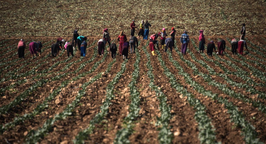
An Area the Size of Tartus and Daraa together can be cultivated; Syrian Agricultural Land: Where is the Increase and Decrease?
10% of the Syrian land that has been cultivated in 2010 remains uncultivated in 2019. Although the rate may seem small compared to all high rates and index numbers recorded during the Syrian crisis, the area we are describing here approximates 520 thousand hectares: i.e.: what is equivalent to the area of Daraa and Tartus combined! An area that can increase the amounts of grain and legume production on average by 900 thousand tons if recultivated.
Tracking the locations of the loss of land according to the governorates seems logical, as the great losses are in tension zones. On the other hand, community stabilization is an important factor in increasing areas, and not only compensating what has been lost as evidenced from the increase recorded in some governorates.
Loss in Tension and Divided Zones!
Half of the uncultivated area is in al-Hasaka, as the regions of south-east Syria have lost 248 thousand hectares from its agricultural land. The vast lands in the governorate can only be served by their people and their stability in their regions. Despite the apparent stability in al-Hasaka, the governorate has lost a large part of its population due to displacement, and it is also witnessing the lowest rates in the return of displaced people to their villages of origin. Practically, displacement in al-Hasaka has approximated 540 thousand people who have left their areas of stability within the governorate to move to other areas. However, by 2020, only 92 thousand of them were left! While hundreds of thousands of hectares are left uncultivated in the south-eastern strip and some areas occupied by Turkey, their farmers are militarized and clustered in areas of displacement!

The afflicted Raqqa also lost 132 thousand hectares of its cultivated land in 2010, by 22%. The lands of al-Raqqa are distributed roughly in terms of areas of control, as the areas in the strip, east and west of the lake and the river, are under a certain control, and its northern part is under another control. As a result, this governorate is a contact point with different agricultural policies and disparate institutional structures in its territory. This makes restoration of land in it slower despite the progress in 2017 after ISIS emerged out of it leaving widespread destruction that reached everything. What makes it harder is that cultivating al-Raqqa was serving to a large extent and was related to government subsidies and finance more than others, as it is mainly irrigation and cotton cultivation areas, and thus, it needs to restore the agricultural infrastructure, finance and standardize procedures. In government-controlled areas, the overall agricultural institutional structure is weak, as for example, in the southeastern countryside of al-Raqqa a plan of wheat cultivation has been set to cover 17200 hectares, but practically, only a little over 7 thousand has been cultivated!
Same goes for Aleppo and Deir Ezzor, where the loss is between 70 – 74 thousand hectares in each. The areas that are out of the control of agriculture and farmers are the regions that are still in the heat of conflict, and if we excluded Idlib, which nearly all of its area is being cultivated, then tension zones are the areas of land loss, and all governorates that are divided in terms of control did not retrieve all of their lands. However, this is not everything, as wide areas from the agricultural lands of other governorates that are considered security stable are still neglected. In Homs and Hama, there are still 80 thousand hectares of land uncultivated: i.e.: what approximates one third of the area of Al-Ghab Plain. These areas are no longer security areas, but vast areas are still dangerous because of mines and some targets that exist in Hama in particular, and that is first of all. Second of all: farmers have not returned to many of the villages from which they were displaced in the governorate’s countryside, hence, those areas are being invested in an illegal, causal and disorganized way without seriously being of service.
Additional Surprising Areas in As Suwayda and Daraa!
On the other hand, there are governorates that witnessed an increase in their cultivated lands between 2010 – 2019, and 4 governorates added areas to agricultural lands that approximated 47 thousand hectares. The largest increase was in As-Suwayda that added 20 thousand hectares to its agricultural areas, which is a large number specifically as a proportion of the overall agricultural land, as the people of As-Suwayda increased the lands of their governorate by nearly 20%! It is also an interesting number compared to the nature of the terrain of the region’s lands, which is difficult to invest or expand. The need to increase food production and the lack of other means of work push towards expanding agricultural areas even in the mountain region. Practically, the number of cultivated areas recorded in 2019 exceeded the highest number recorded in two decades in 2002 by 122 thousand hectares for land cultivation.

The remarkable increase in the areas in As-Suwayda indicates the expansion of the processes of agricultural investment, private finance, and land lease, as those areas cannot be expanded by financing small and mid-sized farmers. Also, the agricultural financing of the government nearly reached nowhere, and As-Suwayda and its countryside are currently far away from (government money). The other remarkable increase is in Daraa, by approximately 13 thousand hectares that constitute 7% of cultivated areas in 2010! Daraa, to which most of its displaced people have returned by a rate of more than 80% of the total recorded displacement movement, and which the nature of the settlement was able to keep its youth in the region, is witnessing important and remarkable agricultural shifts in space, or in yield, which we will return to later.
The second region that witnessed an increase in agricultural areas is Damascus and its countryside, as its cultivated area increased by 12 thousand hectares compared to 2010, and it constituted 10% of the area. Fertile lands of Damascus countryside, the decline in real estate activity that used to devour agricultural land in the countryside, in addition to proximity to market centers and residential communities, and the intensity of the need for food all together make the gains tempting and overcome difficulties that come in the way of expanding agriculture. As a result of the exceptional increase in food prices in the market of Damascus and its proximity to export centers, every meter that can be invested in agriculture is being invested, and the lands that are still dangerous because of mines in some areas of Eastern Ghouta have been compensated in the southern and western countryside of Damascus. Finally, there is also an increase in Tartus, but by lower rates, as areas have expanded by nearly 2000 hectares and a rate of 1.6% compared to 2010, also driven by economic factors.
Conclusion
The recultivation of lands refers to several indications, some of them are economic, indicating the capabilities of agricultural investment and prospective earnings, and others are social, indicating the stability of the population and regaining their sources of income. However, the fact that 520 thousand hectares remain without agricultural investment shows the opposite, as uncultivated lands are concentrated in the following points:
Al-Hasaka; having 248 thousand agricultural hectares from its land without agricultural investment can only be explained by demographic factors in the first place, as many displaced people did not return to their villages which they left during the fight against ISIS in 2016 – 2017. Also, agriculture cannot return without infrastructure in al-Raqqa: mainly irrigation and financing, and both are missing in government-controlled or self-administered zones. In Homs and Hama, reasons are also related to political factors, as the level of return of rural displaced people to their villages is low, and wide areas are being invested indiscriminately and from militias.
As for increases, they occurred in specific areas:
In As-Suwayda; where its areas increased by 20% which is an exceptional rate indicating the existence of local financing for investing agricultural land and the expansion of the phenomenon of land lease. This increase cannot be financed with the participation of farmers only, as the system of remittances may have a role in increasing the capability of rural people to reinvest lands that have been neglected for nearly two decades!
In Daraa; the increase also approximated 7% and 17 thousand hectares also increased due to a local financing movement and agricultural investment. In addition, the labour force of the youth which is required in agriculture is available in both southern governorates under their special situation, and this labour force is missing in other regions, such as: Homs and Hama, specifically from the people of the regions that have been a place of conflict and have become afterwards under government control.
The countryside of Damascus has also expanded its cultivation area by 10%. The main motives may be economic, and may be a result of the high returns of agriculture in the region more than in other areas! The large market and proximity to export centers lets producers increase their prices relatively. The return of displaced rural people to their villages of origin will guarantee the restoration of a significant part of the areas. Also, the stability of the environment and not draining its youth by immigration is a factor that seems effective to the increase. Neglected lands are waiting for their inhabitants to get them back to life before anything else, so that all other agricultural demands will be next.